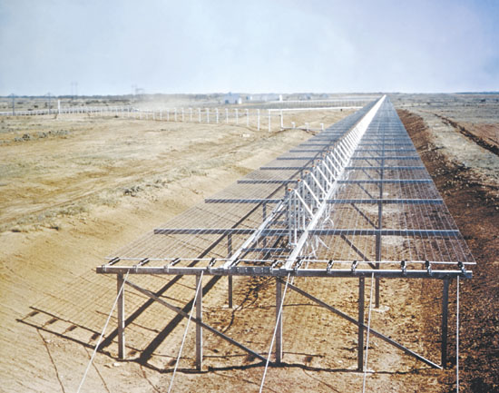
The AN/FPS-133 Air Force Space Surveillance System, colloquially known as the Space Fence, was a U.S. government multistatic radar system built to detect orbital objects passing over America. It is a component of the US space surveillance network, and according to the US Navy was able to detect basketball sized (29.5 inches (75 cm)) objects at heights up to 30,000 km (15,000 nautical miles.)[1]
The system ceased operation in September 2013. Plans for a new space fence are underway with sites at the Kwajalein Atoll in theMarshall Islands, along with an option for another radar site in Western Australia.[2]
The operation's headquarters were at Dahlgren, Virginia, and radar stations were spread out across the continental United States at roughly the level of the 33rd parallel north. Per Wikipedia.
I did not even know about the space fence until I saw a headline about it being closed. It struck me as strange that it was on 33rd parallel. If we live on a globe, would not the equator be a better location or somewhere in the middle? If you look at the flat earth map, the 33rd parallel is in the middle. Antarctic and Arctic are both at 66 degrees so 33 would be in middle. Also you have Roswell, New Mexico on 33rd parallel as well as supposedly the fallen angels landed on Mt. Hermon which is on 33rd parallel.
When the system became operational in 1961, the original frequency was 108.50 MHz (just above the FM broadcast band). In 1965 the "Fence" system was modernized with the operating frequency doubled to 216.98 MHz (just above Channel 13 in the VHF TV broadcast band) to obtain higher resolution and to locate smaller objects. This frequency was used until the Fence was decommissioned in 2013. Per wikipedia. 6 x 6 x 6= 216
As of November 2014, the USAF Strategic Command had "announced data-sharing agreements with at least seven countries and 44 companies, but [the details of] those agreements have [not] been made public" and it is unclear how much of the new Space Fence data will be shared.[1]
Countries with space situational awareness data-sharing agreements in place with the USAF include Australia, Japan, Italy, Canada, France, the Republic of Korea and theUnited Kingdom. It also "has agreements with the European Space Agency and Europe’s Eumetsat weather satellite organization. The new space fence is at 8°43′N 167°44′E.
The new space fence seems to be more inline with a globe earth.
Maybe they want to be more aware of what is going on at outer rim? It is fun to speculate.
No comments:
Post a Comment